Chapter 3
Tranquil and unspoilt places
The South Downs National Park is in South East England, one of the most crowded parts of the United Kingdom. Although its most popular locations are heavily visited, many people greatly value the sense of tranquillity and unspoilt places which give them a feeling of peace and space. In some areas the landscape seems to possess a timeless quality, largely lacking intrusive development and retaining areas of dark night skies. This is a place where people seek to escape from the hustle and bustle in this busy part of England, to relax, unwind and re-charge their batteries.1
Tranquillity
Tranquillity is an aspect of how people experience landscapes, and is an important special quality of the National Park. It is about being among the sights and sounds of nature and has an important role to play in quality of life and people’s health and well-being.
|
Box 3.1 Factors contributing to and detracting from tranquillity Positive factors The openness of the landscape Its perceived naturalness Lack of noise and disturbance The presence of features such as rivers or views of the sea Detracting factors Visibility of urban development and roads Noise and light pollution Other overt signs of human impact |
A general measure of tranquillity, and how to assess it, was developed jointly by the Campaign to Protect Rural England and the Countryside Agency in 2005.2 Based on this approach we can start to develop an understanding of how important the National Park is in the context of a busy and pressured region. We can also start to understand where the areas of greatest tranquillity are being maintained.
In the national range of tranquillity, with a potential ‘top score’ of 150, the National Park sits at around 50.9. Comparisons are difficult, as it is a relative measure. In the context of the most developed part of the south east, those areas of greatest tranquillity are especially important to protect (see Map 3.1).
On the chalk ridge of the eastern and central downs, the highest scores for tranquillity are found on the escarpment, dip slope and within the valleys. This is most notable away from the major settlements and transport networks. Remaining areas of tranquillity are under threat, particularly where the conurbations of the south coast impact upon the adjacent downland. The lowest tranquillity scores are associated with the areas that are close to the conurbations of Brighton, Hove and Worthing.
The Department of Environment, Farming and Rural Affairs (Defra) is in the process of producing ‘noise maps’ to determine the impact of environmental noise, and the effects on the public. At present only the area of the National Park around Brighton has been mapped as part of this project. The mapping does cover some of the major roads that cross or adjoin the National Park including the A23, A24, A27 and the A3 corridors.
See Defra ‘Noise Mapping’ at:
| http://services.defra.gov.uk/wps/portal/noise |
|
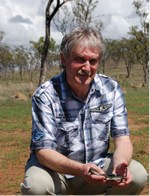
Case Study John Mason
Dr John Mason MBE is a founder member of the British Astronomical Association’s Campaign for Dark Skies and has been campaigning for better quality night-time lighting for over 20 years. “I grew up in an area that is now at the southern edge of the South Downs National Park. In those days it was extremely dark there, with the Milky Way a stunning sight, particularly on summer evenings. It is surely one of the main reasons why I became fascinated by astronomy at an early age. To me, it is just as important to be able to enjoy a clear, dark, star-studded sky as it is to be able to go on a nice walk in the countryside on a Sunday afternoon. For the benefit of everyone who is fascinated by the great beauty and wonder of the night sky, it is vital that we conserve the dark skies of those places we still have within the boundaries of the National Park. This is not just about stargazing, it is also about preserving the night-time environment for the benefit of all the animals, birds and insects that thrive at night. We must ensure that those areas within the National Park which have the darkest skies are protected, and that we have the necessary lighting controls in place to make sure that man-made light doesn’t spoil that view in the future. This will require carefully drafted planning guidelines and enforcement of the controls on night-time lighting that are specified. We should look on those dark places within the National Park as an invaluable resource for everyone who lives and visits here. The South Downs is an area of outstanding natural beauty, and in my opinion, dark skies must be viewed as another of its most important attractions.” |
Map 3.1
The areas of relative tranquillity within the South Downs National Park
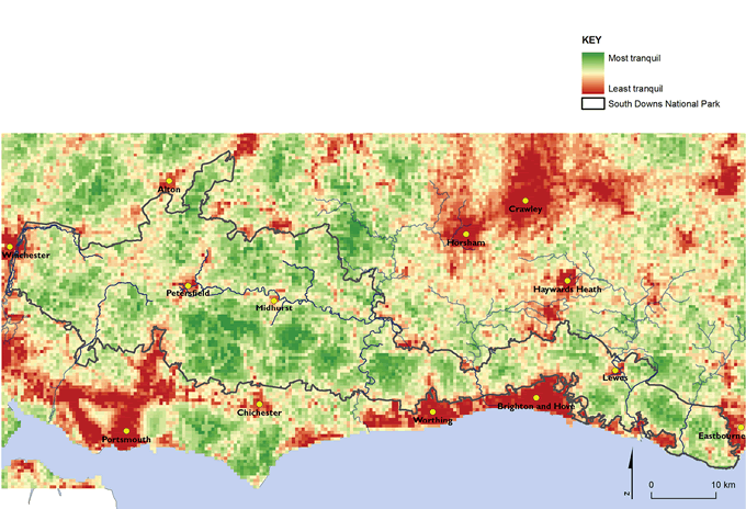
Maps prepared by: GeoSpec, University of Brighton; February 2012.
Source: Campaign to Protect Rural England, 2006
Ordnance Survey Crown Copyright © Licence No. 100050083.
The tranquillity and ‘intrusion’ data compiled by the CPRE remains the principal source to provide a baseline of the current situation within the National Park. It may be necessary to monitor changes in tranquillity within the National Park at a more local level in the future.
Dark night skies
The south east is the most light-polluted region of the UK, with street and outdoor lighting affecting the dark night skies and the yellow glow from our towns and cities being visible for miles around. Map 3.2 shows light pollution for the National Park. Only 1 per cent of the region can be defined as ‘truly dark’ and many areas are totally light saturated. This represents a significant waste of energy. More efficient street lighting in towns and cities can greatly address this issue.
There are a few pockets of dark night skies within the National Park and these are of great value. In areas where dark night skies remain, the National Park is a place to experience the best free light show there is, with bright stars scattered across the heavens.
Map 3.2
Light pollution in the south east
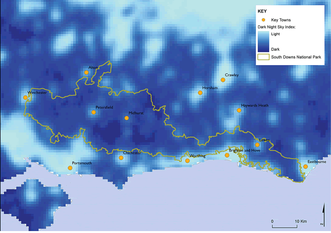
Maps prepared by: GeoSpec, University of Brighton; February 2012.
Source: Campaign to Protect Rural England, 2003
Ordnance Survey Crown Copyright © Licence No. 100050083.
Water Fact File
Water Fact File |
|
Key data: Tranquil and unspoilt places Tranquillity The National Park Authority, with its partners, will monitor changes in tranquillity within the National Park: Key data: Level of tranquillity according to the index of tranquillity. Current position: Measure(s) to be decided based on CPRE data. Data source: Campaign to Protect Rural England (2006) National Tranquillity Mapping, Campaign to Protect Rural England Responsibility for data collection: CPRE and South Downs National Park Authority.
Dark night skies The National Park Authority, with its partners, will map the extent of ‘dark night skies’ and monitor changes in levels of light saturation within the National Park: Key data: Extent of dark night skies within the National Park area. Current position: Measure(s) to be decided based on CPRE data. Data source: Campaign to Protect Rural England (2003) Dark Skies Mapping, Campaign to Protect Rural England Responsibility for data collection: CPRE and South Downs National Park Authority.
|
Footnotes
Click on the footnote number to take you back to your place in the document.
1 South Downs National Park Authority (2011) Special Qualities of the South Downs National Park, South Downs National Park Authority
2 Campaign to Protect Rural England (2005) Mapping Tranquillity: Defining and Assessing a Valuable Resource, Campaign to Protect Rural England